Aguilar, Colorado: Gateway to Cordova Pass and the Spanish Peaks
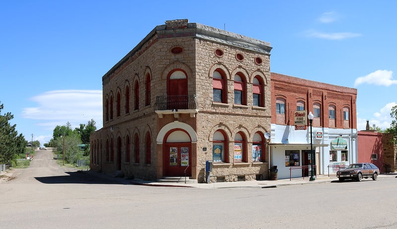
Aguilar sits quietly along I-25 in southern Colorado, tucked between the Wet Mountains to the northwest and the dramatic silhouette of the Spanish Peaks rising on the western horizon. At 6,394 feet elevation in Las Animas County, this small town of roughly 460 residents punches well above its weight in terms of history and access to outdoor adventure. Coal camps once held thousands of workers here; now the same rugged landscape beckons road-trippers, hikers, and history seekers who have learned to exit the interstate and slow down.
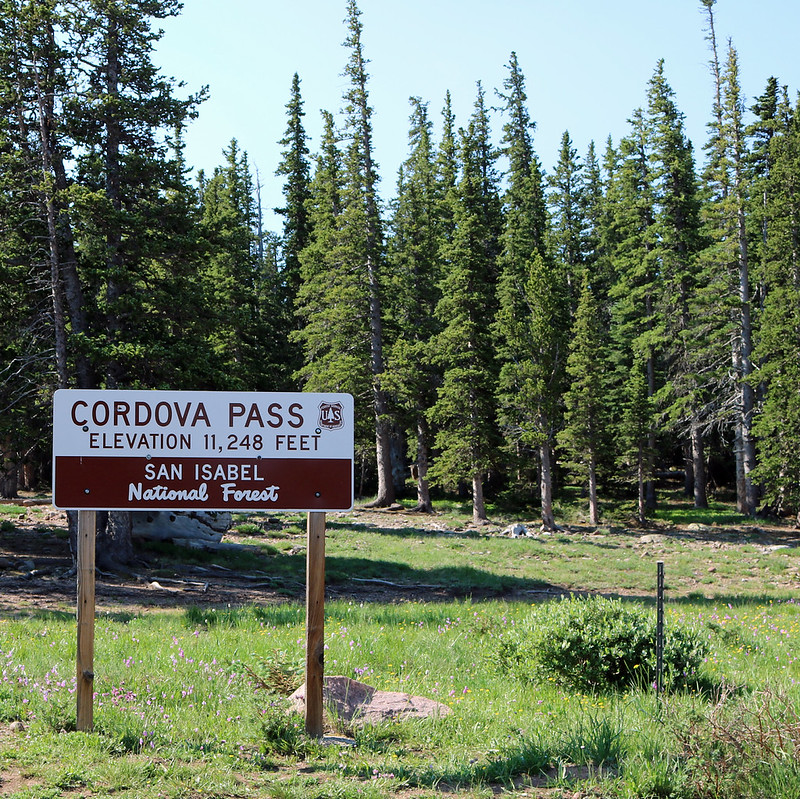
The town marks the eastern entrance to Cordova Pass, an 11,248-foot crossing that arcs westward through the San Isabel National Forest before reconnecting with Colorado Highway 12 near Cuchara. That route — County Road 46, gravel through its middle section — threads through some of the most dramatic geology in southern Colorado, including the Apishapa Arch, a natural tunnel carved right through a volcanic dike by centuries of erosion. Aguilar is, quite literally, the door that opens onto all of it.
Visitors who write Aguilar off as just another freeway exit are missing something real. The town’s coal-era bones are still visible in its modest historic core, and the proximity to the Spanish Peaks Wilderness, the Highway of Legends Scenic Byway, and the Ludlow Massacre National Historic Landmark makes it a surprisingly rich staging point for southern Colorado exploration. Whether you’re planning a Spanish Peaks summit attempt, cruising the Highway of Legends, or chasing the kind of quiet that only small mountain-fringe towns can offer, Aguilar earns an honest look.
Quick Facts
| Elevation | 6,394 feet |
| Population | ~456 (2020 Census) |
| County | Las Animas County |
| Distance from Denver | ~150 miles south via I-25 (approx. 2 hrs 20 min) |
| Nearest Large City | Trinidad, 20 miles south; Pueblo, 60 miles north |
| Founded | 1888; incorporated 1894 |
| Zip Code | 81020 |
History of Aguilar
The land around present-day Aguilar was inhabited long before European settlement, sitting at the edge of the territories that gave way to Spanish and then Mexican land grants along the Apishapa Canyon corridor. In 1864, a trading post called San Antonio Plaza was established at the current townsite, catering to travelers moving through this stretch of southern Colorado. The real transformation came in 1888 when the town was formally founded and named for José Ramón Aguilar, a New Mexico-born state legislator who was among the early boosters of the region. The town was incorporated in 1894.
The discovery of coal seams in the surrounding hills launched a boom that few Colorado small towns could match. By the early 1890s, Aguilar had grown to more than 2,500 residents, supporting four hotels, more than a dozen saloons, multiple churches, a bank, a mortuary, and the kind of civic ambition that comes with sudden industrial prosperity. The Colorado & Southern Railway arrived in 1892, tying Aguilar into regional coal distribution networks and cementing its status as a significant southern Colorado industrial hub. The surrounding mines drew immigrant workers from across Europe — Italians, Slavs, Greeks, and others who left their mark on the town’s cultural character and built structures like the Antonio Lopresto Building that still stands on the main street today.
That prosperity came at a profound cost. Aguilar found itself directly caught up in the Colorado Coal Field War of 1913–1914, one of the most violent labor conflicts in American history. The United Mine Workers of America established a large strike tent colony at Aguilar when mine operators evicted striking workers from company housing. On October 29, 1913, arsonists attacked and destroyed the Aguilar post office and several other town buildings in strike-related violence. The conflict’s bloodiest chapter unfolded just miles to the south at Ludlow, where Colorado National Guard troops and mine company guards attacked the Ludlow tent colony on April 20, 1914, killing approximately 21 people — mostly women and children — in what became known as the Ludlow Massacre. The shock of that event reverberated nationally and helped accelerate federal child labor and eight-hour workday reforms. Today, the Ludlow Massacre National Historic Landmark stands 12 miles south of Aguilar on I-25 as a sobering and essential stop for anyone interested in American labor history.
Outdoor Recreation Near Aguilar
Aguilar’s greatest asset for outdoor enthusiasts is its position as the eastern gateway to Cordova Pass and the Spanish Peaks Wilderness. The country to the west encompasses some of the most varied terrain in southern Colorado: volcanic dike formations radiating from the Spanish Peaks like the spokes of a wheel, pine and spruce forest in the San Isabel National Forest, high-altitude meadows above treeline, and serious summit routes for fit hikers. The access point is County Road 46, which begins west of town and climbs steadily into the mountains.
Cordova Pass and the West Spanish Peak Trail
County Road 46 — the road to Cordova Pass — begins west of Aguilar and climbs through pinyon-juniper scrub before entering the San Isabel National Forest. The road tops out at 11,248 feet at Cordova Pass, where a primitive trailhead serves as the primary starting point for the West Spanish Peak Trail, the most popular route in the Spanish Peaks Wilderness. The trail traverses relatively open terrain above treeline for most of the approach before a steeper push to the 13,623-foot summit. The round-trip distance from Cordova Pass is approximately 6 miles with around 2,400 feet of elevation gain — strenuous but achievable for fit hikers on a clear summer day. Views from the top extend across Las Animas, Huerfano, and Costilla counties, with the Sangre de Cristo Range stretching north and the Raton Mesa visible to the south into New Mexico.
East Spanish Peak (12,708 feet) is a separate summit with its own approach trails, typically accessed from the Wahatoya Trail on the north side. The two peaks together form one of the most distinctive landmarks in southern Colorado — visible from as far as 100 miles away on clear days, they were used as navigation markers by Indigenous peoples, Spanish explorers, and Santa Fe Trail travelers for centuries.
The Apishapa Arch
Along County Road 46 near the pass, the Apishapa Arch is one of the more unusual geological features in southern Colorado — a natural tunnel punched through a volcanic dike by centuries of erosion from Apishapa Creek. The Spanish Peaks are surrounded by more than 400 of these radial dikes, ancient volcanic intrusions that solidified into walls of rock extending up to 14 miles from the peaks themselves. The dikes vary from a few feet to over a hundred feet tall and create an otherworldly landscape unique in Colorado. The arch allows County Road 46 to pass directly through one of them — a quick but memorable transit that signals your arrival in high-country Aguilar territory.
Bear Lake and San Isabel National Forest Camping
About 15 miles west of Aguilar via County Road 46 and then south on Forest Service roads, Bear Lake Campground sits at roughly 11,000 feet in the San Isabel National Forest. The campground operates on a first-come, first-served basis at $25 per night from late May through September. Bear Lake provides fishing for rainbow and brown trout in a scenic high-altitude setting, and a network of multi-use trails from the campground allows for day hikes into the surrounding subalpine terrain. ATV recreation is also permitted on designated trails in the area during summer months.
Dispersed camping (no fee, no facilities) is permitted throughout the San Isabel National Forest away from roads and water sources — a genuine option for those who want solitude without a campground fee. The national forest land west of Aguilar supports healthy populations of mule deer, elk, black bear, and wild turkey. Pronghorn antelope are common on the lower plateau terrain between town and I-25. For wildlife watching, the transition zone between plains and forest in the late afternoon hours is particularly productive.
Note: County Road 46 over Cordova Pass is gravel through its upper section and typically closes November through May or June depending on snowpack. Check conditions with the Pike-San Isabel National Forest San Carlos Ranger District before a spring visit.
The Highway of Legends: Aguilar’s Signature Drive
Aguilar anchors the eastern end of a 39-mile spur that extends from I-25 west over Cordova Pass to connect with Colorado Highway 12, and from there southward through the full Highway of Legends National Scenic Byway to Trinidad. The full loop — exiting I-25 at Aguilar (Exit 30), driving west over Cordova Pass, south through Cuchara and La Veta, and returning via I-25 from Trinidad — covers roughly 80 miles and can be completed in a half-day or stretched into a leisurely full day with stops.
Colorado Highway 12 between Walsenburg and Trinidad has been designated a National Scenic Byway for good reason. The route passes the Francisco Fort Museum in La Veta — an 1862 adobe trading post turned local history museum — the artsy mountain village of Cuchara with its galleries and the Dog Bar & Grill, Monument Lake, and dramatic volcanic dike formations that create a geological spectacle unlike anywhere else in Colorado. The highway also passes through the Stonewall Gap, a narrow canyon cut through a massive volcanic dike that forces the road into a tight passage flanked by walls of dark stone rising over a hundred feet on both sides.
For the full Highway of Legends experience starting from Aguilar: head west on County Road 46 over Cordova Pass (gravel section, clear in summer), descend to Colorado Highway 12 at Cuchara, and follow CO-12 south through the mountain villages to Trinidad. From Trinidad, I-25 north returns to Aguilar in about 20 minutes. This counterclockwise loop gives you the best light on the Spanish Peaks in the morning and on the eastern plains in the afternoon. Allow at least 3–4 hours for the loop with stops; a full day lets you explore La Veta, picnic at Monument Lake, and still make Trinidad for dinner.
Food and Drink
Aguilar is a small town, and honest expectations are in order when it comes to dining. The town itself has limited restaurant options, and most visitors eat in Trinidad (20 miles south) or Walsenburg (25 miles north) for a full sit-down meal. That said, the surrounding Highway of Legends corridor has several worthy stops.
In Cuchara (about 35 miles west via the Cordova Pass route), the Dog Bar & Grill is a beloved local gathering spot known for solid burgers and mountain ambiance. The village also has seasonal lodges with dining rooms, and a small general store. In La Veta (approximately 40 miles west/northwest), an emerging arts-colony scene has brought quality coffee, a local brewpub, and several cafes to what is otherwise a very small town. La Veta’s Main Street has become one of the better surprise dining stops in southern Colorado for travelers who take Highway 12 instead of the interstate.
In Trinidad (20 miles south), the dining scene is more substantial and reflects the town’s Hispanic heritage — several restaurants serve New Mexican-influenced food with the kind of red and green chile that travelers on I-25 often overlook entirely. Trinidad has also developed a small craft food and coffee scene around its beautifully preserved Victorian downtown.
One practical note: pack provisions before heading west over Cordova Pass. There are no services on County Road 46 between Aguilar and Cuchara, and the nearest fuel and supplies on the highway side are in La Veta. Aguilar has a small market and a gas station for basic resupply before you head into the mountains.
Where to Stay in and Near Aguilar
Aguilar itself does not have hotels, but the surrounding area offers options ranging from primitive forest camping to boutique cabins along the Highway of Legends corridor.
Bear Lake Campground (San Isabel National Forest): Approximately 15 miles west of Aguilar via County Road 46. First-come, first-served sites at $25 per night, open late May through September. The closest developed camping to the Cordova Pass trailheads, Bear Lake is a genuine high-country experience at around 11,000 feet with fishing, hiking, and spectacular star viewing on clear nights.
Dispersed Camping (San Isabel National Forest): Free primitive camping is available throughout the national forest west of Aguilar. No fee, no facilities — bring water, pack out trash. The forest roads in this area see light use, making it easy to find solitary sites even in summer.
Trinidad (20 miles south): The most convenient town for motel and hotel accommodations. Trinidad has several chain options including a Best Western and a Holiday Inn Express near I-25, as well as independently owned B&Bs in the Victorian historic district. Trinidad Lake State Park’s campground is also a strong option for campers wanting RV hookups or tent sites with a view.
La Veta and Cuchara (along CO-12, 35–45 miles west): Both towns have bed-and-breakfasts and vacation rental cabins with a more boutique character, surrounded by the Spanish Peaks and the ponderosa pine forests of the San Isabel. Staying in this area puts you in an ideal position for a Highway of Legends multi-day itinerary.
Day Trips from Aguilar
Ludlow Massacre National Historic Landmark (12 miles south via I-25)
The Ludlow Massacre site sits just off I-25 at Exit 27, maintained by the United Mine Workers of America. The monument and preserved “Death Pit” — the cellar where women and children sheltered during the National Guard attack on April 20, 1914 — represents one of the most consequential moments in American labor history. The site includes an interpretive shelter and monument erected by the UMWA. Admission is free; the site is open year-round. For anyone interested in labor history, Colorado’s industrial past, or the Gilded Age more broadly, this is essential. The site is sobering and understated, which makes it all the more powerful.
Trinidad (20 miles south via I-25)
Trinidad is one of Colorado’s most underrated small cities, with a beautifully preserved Victorian downtown built along the Santa Fe Trail. The A.R. Mitchell Museum of Western Art houses one of the finest collections of traditional Western art in southern Colorado. Trinidad Lake State Park, just west of downtown, offers 2,700 acres with camping, fishing for bass and trout, hiking, and seasonal boating. The town has also attracted national attention in recent years for its role as a destination for gender-affirming healthcare — a fascinating and ongoing chapter in a city that has always been a cultural crossroads. Trinidad is worth a half-day at minimum.
La Veta and the Francisco Fort Museum (40 miles via CO-12)
La Veta’s Francisco Fort Museum preserves the 1862 adobe trading post and military post established by Colonel John Francisco in the Cucharas Valley. The museum tells the story of the San Luis Valley borderlands from Spanish colonial times through the late 19th century. The town itself has evolved into a small but thriving arts community, with galleries, studios, and a low-key downtown that rewards a leisurely stroll. La Veta is accessible via Walsenburg and I-25 to CO-160 (approximately 35 miles, mostly paved), or via Cordova Pass (more scenic, 40 miles, partially gravel).
Walsenburg and Lathrop State Park (25 miles north via I-25)
Walsenburg is the Huerfano County seat and the northern anchor of Spanish Peaks Country. Lathrop State Park, just west of town, features two reservoirs (Martin Lake and Horseshoe Lake) stocked with rainbow trout, along with walking trails, boating, a swim beach, and a nine-hole golf course — a remarkably complete recreation area for a town of 3,000. The Walsenburg Mining Museum documents the region’s coal heritage in the old city jail building, a fittingly ironic setting. Walsenburg is also the junction for Colorado Highway 12, making it the starting point for the Highway of Legends if you’re approaching from the north.
Planning Your Visit to Aguilar
Getting There: Aguilar sits directly on I-25 at Exit 30, roughly 150 miles south of Denver (approximately 2 hours 20 minutes in normal traffic), 20 miles north of Trinidad (about 20 minutes), and 25 miles south of Walsenburg (about 25 minutes). From Pueblo, it’s approximately 60 miles south on I-25. There is no commercial air service; Colorado Springs Airport (about 90 miles north) is the closest regional airport with connections to major hubs.
Getting Around: A personal vehicle is essential. County Road 46 west toward Cordova Pass is paved for the first several miles before transitioning to maintained gravel. A standard passenger car can handle the route in dry summer and fall conditions, though higher clearance is helpful on the rougher sections. The gravel portion is not suitable for low-clearance vehicles or in wet weather. Do not attempt Cordova Pass in winter or early spring without checking current conditions with the San Carlos Ranger District.
Best Time to Visit: Summer (June through September) is the prime season for Cordova Pass, Bear Lake, and Spanish Peaks hiking. The pass typically opens in late May or early June depending on snowpack and is clear through October in most years. July through early August is peak wildflower season on the high-country trails, with blue columbine, Indian paintbrush, and alpine sunflowers lining the route to the summit. Fall is excellent — cooler temperatures, aspen color along the Highway of Legends in late September and early October, and significantly fewer crowds than summer. Winter closes the high pass route but I-25 and the town itself remain accessible year-round.
Services: Aguilar has a post office, a small market, and a gas station — enough for basic resupply. Fill your tank before heading west on County Road 46; the next services are in La Veta, about 35 miles by the mountain route. Cell service is reliable on I-25 and in town but limited on County Road 46 above the first few miles.
Useful links for planning your visit to Aguilar:
- Highway of Legends Scenic Byway — Colorado DOT
- Pike-San Isabel National Forest — Road and Trail Conditions
- Spanish Peaks Wilderness Trails — AllTrails
- Trinidad Lake State Park — Colorado Parks & Wildlife
Related Articles
If you’re exploring southern Colorado beyond Aguilar, these GoColorado guides cover the rest of Spanish Peaks Country and the Highway of Legends corridor: