Buena Vista, Colorado: The Whitewater Capital at the Foot of the Collegiate Peaks
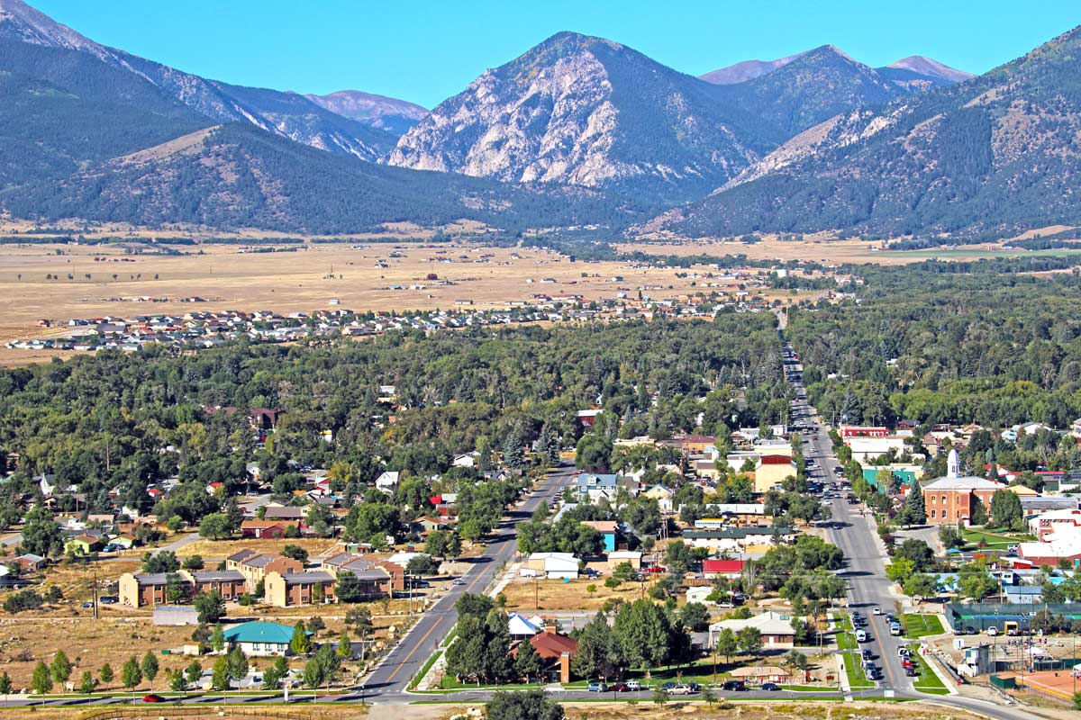
Tucked into the sun-soaked bowl of the Upper Arkansas River Valley, Buena Vista sits quietly between towering, snow-capped peaks on one side and the wild, rushing Arkansas River on the other. It’s the kind of place that sneaks up on you — a small Colorado town that’s somehow turned into one of the top adventure spots in the Rocky Mountain West. At nearly 8,000 feet, Buena Vista lives up to its motto, “8,000 Feet Above Average,” and honestly, its name nails it. The views here really are something else.
Look west and you’ll see the Collegiate Peaks — Mount Harvard, Mount Princeton, Mount Yale, Mount Columbia, and Mount Oxford. These mountains aren’t just impressive; together, they make up the highest cluster of 14,000-foot summits in the lower 48. Swing your gaze east and the Arkansas River cuts south, carving out the granite walls of Browns Canyon National Monument. The river’s rapids here are legendary — some of the best whitewater in the country, right in Buena Vista’s backyard.
After a day out on the water or in the mountains, you can soak your tired bones in one of the area’s natural hot springs. It’s the perfect way to recover from whatever adventure you chased. Sure, the town is small — just under 3,000 people live here year-round — but Buena Vista more than makes up for its size. The outdoor action, the history, the jaw-dropping scenery… it all adds up. Most folks leave wondering why they waited so long to visit in the first place.
Quick Facts
| County | Chaffee County |
| Distance from Denver | 120 miles southwest via US-285 (approximately 2 hours) |
| Distance from Colorado Springs | 100 miles west via US-24 (approximately 1 hour 45 minutes) |
| Elevation | 7,965 feet (2,428 m) — motto: “8,000 Feet Above Average” |
| Population | 2,855 (2020 census); estimated 3,127 in 2024 |
| Incorporated | November 13, 1879 |
| Name Origin | Spanish for “Beautiful View” (locally pronounced BEW-nuh VISS-tuh; often called “BV”) |
| Notable Feature | Colorado’s whitewater rafting capital; surrounded by the Collegiate Peaks, the highest concentration of 14,000-foot mountains in the contiguous United States |
| Major River | Arkansas River — Colorado’s most rafted river, running directly through and south of town through Browns Canyon National Monument |
| Nearby 14ers | Mount Harvard (14,420 ft), Mount Columbia (14,073 ft), Mount Yale (14,196 ft), Mount Princeton (14,204 ft), Mount Oxford (14,160 ft) |
From Ute Territory to Railroad Boomtown: The History of Buena Vista
The Upper Arkansas River Valley was Ute territory for centuries before European contact — a high-altitude homeland of remarkable abundance, where the river provided water and fish, the valley floor supported game, and the mountains offered spiritual significance as well as seasonal hunting grounds. Spanish explorers began filtering into the region as early as 1725, and Anglo-American trappers and scouts followed in the early 19th century, drawn by the same river corridor that would eventually become the primary avenue of settlement. The area that would become Buena Vista was first homesteaded in 1864, when settlers arrived not for mineral wealth but for the fertile alluvial soils along the Arkansas and Cottonwood Creek — an agricultural foundation that would ultimately give the valley more economic stability than the purely mining-dependent towns to the north.
The true founding of Buena Vista came in 1879, triggered by the great Leadville silver boom unfolding 35 miles to the north. When massive silver deposits were discovered in the mountains above Leadville, the Arkansas River Valley transformed almost overnight from a quiet agricultural corridor into a churning supply line. Buena Vista was platted in 1879 as a service town for the flood of miners, speculators, and railroad workers pushing toward the silver fields, and it incorporated formally on November 13 of that year. The Denver & Rio Grande Railroad arrived in 1880, and at peak chaos Buena Vista had three railroad hubs and a reputation for rowdiness that attracted equal parts commerce and mayhem. The early years were rough: Sheriff Morgan and his deputy were perpetually occupied wrangling the “ruffians, thieves, outlaws and drunks” that the mining economy attracted, and the violence occasionally turned fatal.
One of Colorado’s more colorful episodes of frontier governance played out here in 1888, when Chaffee County voters moved the county seat from Granite to Buena Vista. The residents of Granite refused to surrender the courthouse records. In the dead of night, a group of Buena Vista men commandeered a train engine with a flatcar, rode to Granite, kicked in the courthouse door, and hauled everything back — furniture included. Buena Vista served as county seat until 1928, when Salida’s larger population reclaimed the honor by popular vote. Despite the loss, Buena Vista had already developed the infrastructure of a genuine small city: electricity by 1888, telephone service by 1894, schools, parks, and Colorado’s first state reformatory, built just outside town in 1891.
As silver mining collapsed in the early 20th century and the railroad era wound down, Buena Vista’s agricultural economy provided a cushion that purely mining-dependent towns never had. The town settled into a quieter rhythm, its Victorian-era storefronts and courthouse slowly acquiring the patina of history rather than the dust of abandonment. The modern identity of Buena Vista as a recreation and adventure destination began taking shape in the 1970s and accelerated in the 1990s and 2000s, as Colorado’s outdoor recreation economy grew and the Arkansas River’s world-class whitewater drew a national following. The designation of Browns Canyon as a National Monument in 2015 formalized what paddlers and rafters had known for decades: BV sits at the center of one of the most spectacular river corridors in North America. Today, the population of Buena Vista has more than doubled from its early-20th-century low, driven by the same combination of natural beauty and adventure that the valley’s Ute inhabitants recognized long before the first settler arrived.
The Arkansas River: Colorado’s Whitewater Capital
The Arkansas River is Colorado’s most rafted waterway, and Buena Vista is its undisputed capital. The river runs directly through and south of town, offering an extraordinary range of whitewater experiences within a short drive of downtown — from gentle family floats to Class V rapids that challenge even the most experienced paddlers. The diversity of the Arkansas is a large part of what makes Buena Vista so exceptional: the same river that carries children through Browns Canyon on their first whitewater adventure can, a few miles upstream, pin experienced kayakers in technical Class IV drops that demand complete focus and technical skill.
Browns Canyon National Monument, designated by President Obama in February 2015, is the crown jewel of Arkansas River rafting and one of the most celebrated sections of whitewater in the United States. The monument encompasses 21,586 acres of pristine granite canyon, backcountry forest, and river corridor between Buena Vista and Salida, and the section of river that runs through it offers Class II-III rapids ideal for families and beginners — Zoom Flume, Big Drop, and the Toilet Bowl among the best-known — set against walls of brown granite rising in spires above the water. Between rapids, the canyon opens into calm pools where bighorn sheep, elk, golden eagles, and peregrine falcons can be spotted on the canyon walls and riverbanks. The Browns Canyon half-day trip, running approximately three hours on the water, is the single most popular rafting trip in Colorado and the recommended starting point for first-time Arkansas River visitors.
For paddlers seeking more intense experiences, the Arkansas offers two celebrated advanced sections within easy reach of Buena Vista. The Numbers, located upstream near the headwaters, packs seven major Class IV+ rapids into a stretch of river so continuous that the rapids were numbered rather than named. The section is characterized by steep drops, narrow channels, and almost no recovery time between rapids — a test of endurance and technical paddling best suited to experienced participants age 15 and older. The Pine Creek section, downstream of The Numbers, escalates to Class V and is considered among the most technically demanding commercially rafted whitewater in Colorado, with the famous Pine Creek rapid demanding precise lines from guides and experienced paddlers alike.
Beyond guided rafting, the Arkansas River in and around Buena Vista supports a rich ecosystem of river recreation. The Buena Vista Whitewater Park, located right in town, provides a wave feature and playboating opportunities for kayakers year-round. Anglers pursue the river’s Gold Medal trout waters, which are stocked with rainbow, brown, and cutthroat trout and fish best in early morning and late afternoon during summer, or throughout the day in the productive late winter and early spring months. Stand-up paddleboarders and inflatable kayakers join the mix in the calmer sections, and the riverbanks throughout the Arkansas Headwaters Recreation Area offer miles of walking, birding, and camping opportunities at sites including Ruby Mountain and Hecla Junction, both of which provide direct river access and stunning canyon views.
The Collegiate Peaks: Hiking America’s Highest Mountain Range
No other valley in Colorado offers what Buena Vista does in terms of immediate proximity to 14,000-foot peaks. The Collegiate Peaks — a subsection of the Sawatch Range named for the universities whose endowments and expeditions first mapped them in the 19th century — rise directly west of town in one of the most visually arresting mountain panoramas in the Rocky Mountain West. Mount Harvard at 14,420 feet is the third-highest summit in the contiguous United States and the tallest of the group; Mount Princeton at 14,204 feet is perhaps the most visually dramatic, its white chalk cliffs visible from the valley floor on clear days; Mount Yale (14,196 ft), Mount Columbia (14,073 ft), and Mount Oxford (14,160 ft) complete the quintet. Chaffee County as a whole contains 15 easily accessible 14ers, a concentration found nowhere else in the lower 48 states.
The standard routes up the Collegiate Peaks begin from trailheads accessible via well-maintained forest roads west of Buena Vista, and most involve 8- to 12-mile round trips with 3,500 to 4,500 feet of elevation gain. Mount Yale’s standard route via the Denny Creek trailhead is one of the more accessible Collegiate climbs, with well-marked trail and a relatively straightforward summit approach. Mount Harvard requires a longer approach but rewards with expansive views across a 360-degree panorama that, on clear days, encompasses dozens of surrounding peaks. For visitors new to 14er hiking, Mount Belford to the north offers a slightly gentler introduction to high-altitude summit hiking above Buena Vista. An early start is essential — ideally at the trailhead by dawn — both to avoid the afternoon thunderstorms that develop reliably over the summits in July and August and to secure trailhead parking before the crowds arrive on summer weekends.
Cottonwood Pass, reached via County Road 306 directly west of downtown Buena Vista, provides one of the most accessible and spectacular scenic drives in central Colorado. The paved road climbs from town to a summit at 12,126 feet on the Continental Divide — one of the highest paved passes in the United States — through a succession of increasingly dramatic alpine environments, from spruce-fir forest through open tundra to the windswept divide itself, where panoramic views extend in all directions across the high country. The pass is open seasonally from late spring through early fall, and its closure during winter transforms the road into a beloved fat biking and snowshoeing corridor. On the far side, Cottonwood Pass descends to Almont, from which Gunnison lies 20 minutes south and Crested Butte 20 minutes north — making a Cottonwood Pass crossing one of the most scenic ways to connect Buena Vista with the Gunnison Valley.
Hot Springs: Soaking in the Shadow of the Sawatch
One of Buena Vista’s most distinctive features is its proximity to two outstanding natural hot springs resorts, each with its own character, and both within a short drive of downtown. The combination of world-class adventure recreation and geothermally heated soaking pools — the ability to spend the morning running Class IV rapids or summiting a 14er and the afternoon steaming in pools with mountain views — is available in very few places in Colorado and is central to BV’s appeal as a destination.
Cottonwood Hot Springs, located eight miles west of downtown at the base of Cottonwood Pass along County Road 306, is the more intimate and rustic of the two options — a natural hot springs retreat with multiple soaking pools of varying temperatures set along Cottonwood Creek, surrounded by aspen groves and the forested lower flanks of the Collegiate Peaks. The resort offers overnight accommodations ranging from motel rooms and cabins to tent camping, and its smaller scale and natural setting give it a quiet, restorative atmosphere that makes it a favorite among locals seeking a genuine getaway rather than a resort experience. Soaking in one of the creekside pools as snow falls through the aspens in autumn is one of the quintessential Buena Vista experiences.
Mount Princeton Hot Springs Resort, located 20 minutes south of BV near Nathrop along County Road 162 in Chalk Creek Canyon, is the larger and more amenity-rich of the two. The resort features six separate soaking pools of varying temperatures, a cold plunge, a 400-foot water slide open in summer, creekside natural soaking pools set directly in Chalk Creek’s current, spa treatments, dining, and overnight accommodations including lodge rooms and private cabins. The dramatic chalk cliffs of Mount Princeton rise immediately above the resort grounds, creating a backdrop that borders on theatrical. The creekside pools — natural rocky depressions in the streambed filled with geothermally heated water, with the cold creek flowing around and through them — are among the most memorable natural soaking experiences in Colorado.
St. Elmo and the Ghost Towns of Chalk Creek Canyon
Approximately 19 miles southwest of Buena Vista via County Road 162, past Mount Princeton Hot Springs and through the narrowing granite walls of Chalk Creek Canyon, lies St. Elmo — one of the best-preserved and most atmospheric ghost towns in the American West. Originally called Forest City when it was founded in 1880, the town was renamed and incorporated as St. Elmo shortly after its founding and grew rapidly as gold and silver mines opened throughout the surrounding mountains. At its peak around 1881, St. Elmo supported approximately 2,000 residents, a full complement of saloons, dance halls, and mercantile establishments, and its own rail service along the Chalk Creek corridor connecting to the broader railroad network.
The closure of the railroad through Chalk Creek Canyon in 1926 sealed St. Elmo’s fate, and the population dwindled to almost nothing over the following decades. What distinguishes St. Elmo from most Colorado ghost towns is the remarkable state of preservation of its remaining structures: 43 original buildings still stand along the main street, including the old saloon, the courthouse and jail, the mercantile, and numerous private homes, their weathered wood facades and collapsed interiors lending an authenticity to the town’s desolation that more heavily restored ghost towns lack. The General Store operates seasonally each summer, providing the curious experience of purchasing cold drinks and souvenirs in a Victorian-era building while resident chipmunks — legendarily bold and entirely accustomed to visitors — investigate your bags. St. Elmo is accessible year-round, with the road plowed through winter, and offers a direct gateway to Tincup Pass for visitors with four-wheel-drive vehicles willing to cross the Continental Divide into the Taylor River country.
The surrounding Chalk Creek Canyon area contains additional historic sites for those interested in the region’s mining heritage. The ruins of Hancock and the Mary Murphy Mine are accessible via jeep roads above St. Elmo, and the Alpine Tunnel — a 1,772-foot railroad bore through the Continental Divide completed in 1881 at 11,523 feet, one of the engineering marvels of the Colorado narrow-gauge era — can be reached by a 5.6-mile trail from Hancock, passing panoramic alpine terrain throughout. Agnes Vaille Falls, a short hike along County Road 162 between Mount Princeton Hot Springs and St. Elmo, provides a pleasant waterfall stop on the canyon drive.
Downtown Buena Vista: Local Life on the River
Downtown Buena Vista occupies a compact and walkable grid of historic streets centered on East Main Street, where Victorian-era commercial buildings — many of them listed on the National Register of Historic Places through the Buena Vista Heritage organization founded in 1974 — house an eclectic mix of outfitters, galleries, restaurants, and locally owned shops. The old Chaffee County Courthouse, the building whose threatened demolition in 1974 galvanized the historic preservation movement in BV, now operates as the Buena Vista Heritage Museum, housing exhibits on the town’s railroad and mining history, Victorian-era artifacts, and rotating displays on the natural and cultural history of the Upper Arkansas Valley.
The local dining and brewery scene punches well above its weight for a town of under 3,000. Eddyline Brewery has become one of the anchor institutions of BV’s social life, with two locations — one on South Main Street with a full restaurant and riverfront patio — producing a well-regarded lineup of craft beers that includes the beloved Juicy IPA and River Runner alongside wood-fired pizzas and a full menu. On summer evenings it’s common to find the patio filled with river guides still in their dry gear, comparing lines and stories from the day’s runs while the sun drops behind the Collegiate Peaks. House Rock Kitchen brings elevated mountain cuisine to the downtown main street, while Simple Eatery offers the kind of carefully sourced, locally driven cooking that has become a signature of Colorado’s better mountain town dining scenes. Biggies, a beloved local institution hidden in a downtown alley, serves gourmet sandwiches to an intensely loyal following.
The South Main development along the river has added a newer dimension to Buena Vista’s character — a planned riverfront district with a climbing wall, event space, trails connecting directly to the Arkansas River corridor, and a mix of businesses that brings outdoor recreation infrastructure right into the urban fabric of the town. The Surf Hotel, the most upscale lodging option in BV, anchors this district with a design aesthetic that combines mountain character with modern amenity. The annual Paddlefest in May celebrates the start of high-water rafting season with competitions, clinics, and a river festival atmosphere that draws paddlers from across the region. Gold Rush Days in August honors the mining heritage with a full weekend of events including a parade, competitions, and live music in the park.
The Comanche Drive-In Movie Theater, operating just outside Buena Vista each summer, holds the distinction of being the highest-elevation drive-in theater in the United States — a distinction that makes its summer Friday-through-Tuesday screenings one of the most characteristically Colorado evening experiences in the state, with the dark skies of the Upper Arkansas Valley providing a starfield backdrop that no urban multiplex can match.
Planning Your Visit
Getting There: Buena Vista sits 120 miles southwest of Denver via US-285 South through Fairplay, a drive of approximately 2 hours through some of Colorado’s most scenic high country. From Colorado Springs, take US-24 West through Hartsel and Johnson Village for approximately 100 miles, about 1 hour 45 minutes. The nearest major airports are Denver International (2 hours) and Colorado Springs Airport (2 hours). Gunnison-Crested Butte Regional Airport is accessible via Cottonwood Pass when open (seasonal), approximately 90 minutes.
Getting Around: Buena Vista is a small, walkable downtown, though a vehicle is essential for accessing trailheads, the hot springs, St. Elmo, and river access points. Most rafting companies offer shuttle service from downtown. Cottonwood Pass Road (County Road 306) is paved and accessible to all vehicles when open. St. Elmo and the Chalk Creek Canyon area are accessible via a well-maintained gravel road suitable for most vehicles, though a 4WD or high-clearance vehicle is recommended for exploring beyond St. Elmo.
Best Time to Visit: Late May through September is peak season, when the Arkansas River is running strong, all trailheads are accessible, Cottonwood Pass is open, the hot springs resort pools are fully operational, and St. Elmo’s General Store is open. June and July bring the highest river flows and the most intense whitewater. Mid-September to mid-October offers spectacular fall color in the aspen groves on the hillsides and passes, with cooler temperatures and dramatically smaller crowds. Winter provides a quieter BV with excellent snowshoeing and fat biking on the closed Cottonwood Pass road, snowmobiling on hundreds of miles of backcountry trails, and year-round access to both hot springs resorts.
Altitude Advisory: Buena Vista sits at nearly 8,000 feet, and the activities that draw most visitors — 14er hiking, passes above 12,000 feet, and vigorous river sports — take place at even higher elevations. Visitors arriving from lower elevations should plan to spend at least one night acclimatizing before attempting strenuous activity. Drink plenty of water, apply sunscreen generously (UV radiation increases significantly with elevation), and descend immediately if symptoms of altitude sickness develop.
Lodging: Buena Vista’s lodging ranges from the upscale Surf Hotel on the South Main riverfront district to a solid selection of locally owned inns, motels, and bed-and-breakfasts in and around the historic downtown. Both Cottonwood Hot Springs and Mount Princeton Hot Springs offer overnight accommodations for visitors who want to build their stay around the springs. Camping is outstanding throughout the area, with developed sites at Ruby Mountain, Hecla Junction, and numerous Forest Service campgrounds near the Collegiate Peaks trailheads.
Whether you are floating a family raft through the granite spires of Browns Canyon, slogging up the talus slopes of Mount Harvard toward a summit that feels like the top of the world, soaking in a steaming creek-side pool beneath the chalk cliffs of Mount Princeton, walking the silent main street of St. Elmo in the golden light of a September afternoon, or simply sitting on Eddyline’s patio watching the last alpenglow fade from the Collegiate Peaks over a cold IPA, Buena Vista delivers Colorado mountain experiences of the first order. It is a town whose beauty has earned its name many times over and whose future, shaped by adventure, community, and a remarkably intact natural setting, looks as bright as the high-altitude sun above the Arkansas Valley.
Related Articles
Explore more Colorado adventures and expert guides:
- Complete Guide to Arkansas River Rafting – Section-by-section breakdown and outfitter recommendations
- Browns Canyon National Monument: A Complete Guide to Colorado’s Newest Monument
- Hiking the Collegiate Peaks: A Guide to Colorado’s University 14ers
- Arkansas River Whitewater Rafting: From Beginners to Class V
- Salida, Colorado: Art, Adventure, and the Arkansas River
- Elmo Ghost Town: Colorado’s Most Accessible Step Back in Time
- Cottonwood Pass: Crossing the Continental Divide Above Buena Vista